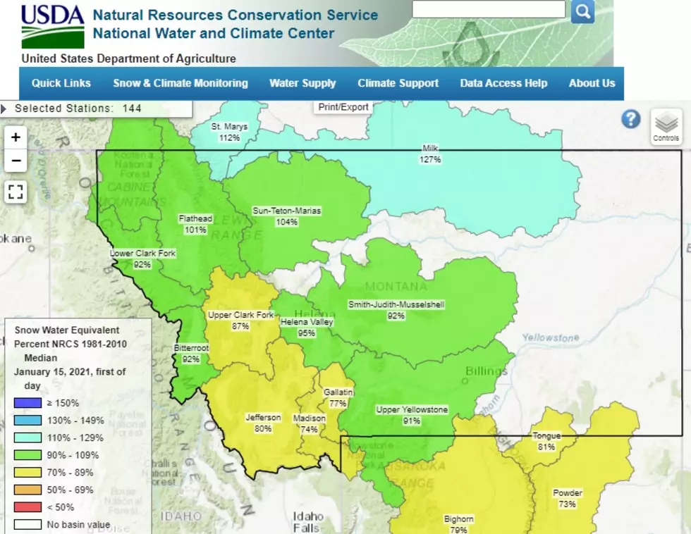
Gallatin Basin: Snow Water Equivalent Only 77% of Normal
We've got some snow dancin' to do. As of January 15th, the Gallatin Basin isn't getting the "snow water equivalent" that we should be.
(The data and numbers used here are directly from the USDA, unless otherwise stated. Percentages will certainly change as the winter season continues. You can check the daily, updated percentages on the USDA Snow Water Equivalent Chart here.)
All the snowpack details are gathered through the SNOWTEL network (SNOwpack TELemetry.) This data is then used to forecast how areas will fare during runoff in the Spring.
In simple terms, it would be great to know that your mountains are "soaked" and packed with tons of snow. Having a high percentage probably indicates a better position to be in for the summer/fall fire season.
At this point, it appears that most of southwest Montana isn't in great shape...water-wise. NOT ALL basins are in bad shape, but the Gallatin Basin along with the Madison Basin aren't without concern. As you can see from the chart below, as of January 15th, 2021:
- Gallatin Basin: 77% of normal
- Madison Basin: 74% of normal
- Jefferson Basin: 80% of normal
- Upper Clark Fork Basin: 87% of normal
- Upper Yellowstone Basin: 91% of normal
- On the other end of the spectrum (the good news): the Kootenai, Flathead, St. Marys, Sun-Teton-Maraias and Milk basins are all currently sitting above 100% of normal.
Although not yet ideal, January appears to put Montana in a slightly better water position that December. December 2020 was ugly. You can take a look at the monthly maps here to see for yourself via the West Wide Drought Tracker from the University of Idaho.
You can sign up for email updates from the USDA Snow Program.
More From The Moose 94.7 FM